
UTM Vega Fly — Drone Pilot Flight Authorization App
Mobile and Desktop
Project Background
UTM Vega Fly is a mobile app designed for drone pilots who need to understand where they can fly, register their activity, request flight authorization, and operate safely in the field.
I designed the app from scratch, including the product structure, UX flows, UI design, and the full mobile experience in Figma. I planned the end-to-end user journey and translated complex airspace rules and approval processes into a clear, guided app experience for drone pilots.
I also created the illustrations, visual assets, and supporting graphic elements used throughout the app, building a visual language that feels clear, approachable, and connected to the Vega ecosystem.
The goal was to make flight authorization more accessible, reduce uncertainty for pilots, and help them understand where they can fly, what areas are restricted, and how to receive approval before operating a drone.
My Role:
Lead Product Designer / Product Design Manager
Tools:
Figma, FigJam, Adobe Photoshop
Date:
2024–2025


Create Flight Plan
I designed a guided flight-planning flow that helps drone pilots create and submit flight requests directly from the map. Users can define the flight area, set mission parameters, review restrictions, and understand the expected approval outcome before submitting.
This was a complex UX challenge: the flow combines map interaction, area drawing, mission settings, regulatory restrictions, and approval logic inside a small mobile interface. A key goal was to prevent users from submitting flight requests that the system could already identify as unlikely to be approved.
By surfacing no-fly zones, restricted areas, conflicts, and denial reasons early in the flow, the app helps pilots clearly understand where their flight can or cannot be approved before they submit it. This reduces uncertainty, avoids unnecessary requests, and makes the authorization process faster and more transparent.


Sign In
The sign-up and sign-in flow for Vega Fly was relatively complex, involving multiple steps, screens, and verification stages. To make the experience clearer, friendlier, and less technical, I designed an illustration-led flow that made the process feel more engaging and approachable. Later, as the flow became even more complex, some of the illustrations were reduced, while the main goal remained the same: turning a complicated process into a clearer and more pleasant user experience.
The flow also included supporting emails sent to users during the registration process, such as verification, sign-up, and password reset emails.


Reset password


At This Location
I designed the At This Location feature to help drone pilots quickly understand whether they can fly in a specific area before creating a flight request.
By tapping a point on the map, users can view all relevant information for that exact location, across two focused sections: Airspace and Weather. The Airspace section shows whether the area is clear, controlled, restricted, or part of a no-fly zone, while the Weather section displays flight-related conditions such as temperature, wind, visibility, rain, sunrise, sunset, forecast data, and whether the conditions are good or bad for flying.
The goal was to make complex airspace and weather information easier to understand in context, reduce uncertainty, and help users avoid submitting flight requests that are likely to be denied.


Flight Conflict Resolution
A safety feature that helps pilots detect and resolve flight conflicts directly during flight planning.
When the app identifies a potential issue, such as a route crossing a restricted area or conflicting zone, it alerts the pilot and suggests an adjusted route. The pilot can apply the solution, edit it manually, or cancel the change, keeping the user in control while still guiding them toward a safer flight path.
The goal was to make complex airspace restrictions easier to understand and reduce the risk of submitting unsafe flight plans. Instead of leaving pilots to solve conflicts manually, the app provides clear feedback, visual context on the map, and a guided correction flow before the flight is approved.


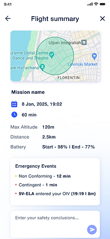
My Flights & Flight Summary
A personal flight area that gives pilots access to their upcoming and completed flights in one place.
Users can review a daily summary, search through their flights, and quickly understand key information such as total flight time, completed flights, dates, times, drone name, and flight status
When opening a specific flight, pilots can see a detailed summary with the flight area on the map, mission details, altitude, distance, battery usage, approval status, and safety or emergency events.
The goal was to give pilots a clear record of their flight activity, helping them track past flights, prepare for upcoming ones, and review important information after a flight is completed.

Onboarding
I designed the Vega Fly onboarding experience from scratch in Figma, including the UX flow, UI screens, and the full illustrated visual direction.
I also personally drew and illustrated all of the onboarding visuals, creating a friendly and approachable layer that helps explain a technical, regulation-heavy product in a simpler way.
The onboarding introduces key app capabilities such as requesting flight authorization, connecting a drone and RID, and using the dashboard, analytics, and logbook — helping drone pilots quickly understand what they can do in the app from the first interaction.


AR Drone Identification
An augmented reality feature that allows pilots to identify drones through the phone camera and see live airspace information directly on top of the real-world view.
By pointing the device toward the sky, pilots can see detected drones with key operational data such as drone name, altitude, distance, and additional flight information. Selecting a drone opens a focused detail panel, giving the pilot a clearer understanding of the aircraft and its position without leaving the live AR view.
The goal was to create a more immersive and immediate way to connect what pilots see in the field with Vega’s digital airspace data — improving awareness, confidence, and real-time understanding during flight.


Outcome
Vega UTM: Fly was designed from scratch as a mobile app for drone pilots who need to understand where they can fly, request flight authorization, and operate more safely in the field.
The product was shaped by user research with drone pilots. We studied their real needs and pain points, and used those insights to design a clearer mobile experience for planning flights, understanding restrictions, requesting approvals, and operating with more confidence.
Across the app, I planned the product structure, UX flows, UI design, and full mobile experience in Figma. I also created the visual language, illustrations, visual assets, and supporting graphic elements used throughout the product.
The result is a clear and approachable app that helps pilots understand how to plan and operate a flight with confidence. Key flight parameters are accessible throughout the experience, making it easier to define flight areas, understand restrictions, register drones and RID devices, receive alerts, resolve route conflicts, identify drones through AR, and review flight activity.